Return to site home page
 |
 |
 |
 |
 |
| Route | People, Fauna | Flora | Arc Dome Wilderness Views | Wilderness Protection Advocated |
|
|
|
|
|
|
| Route | People, Fauna | Flora | Arc Dome Wilderness Views | Wilderness Protection Advocated |
| www.desert-survivors.org
Desert Survivors: "experience - share - protect" Trips for: backpacking, day hiking, carcamping, service, exploration, monitoring. Desert trail route: Contiguous route from Mexico/California border to Nevada/Oregon border. |
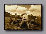
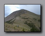
The Toiyabe Range is the longest mountain range in Nevada, forming a high crest that runs roughly 90 miles from the Town of Austin in the North to Arc Dome Wilderness in the South. The 72 mile Toiyabe Crest Trail is a National Recreation Trail and the longest continuous trail in Nevada. The peaks hold snow well into the summer - four rise above 11,000 feet to offer outstanding views. Images in this web site were taken during a trek August 6-11, 2005 organized by Desert Survivors www.desert-survivors.org a desert conservation organization. Backpackers on this trek required less than 6 liters of water to be carried at a time, per person, so pack weights for many were under 45 pounds at trip beginning. |
| www.fs.fed.us/r4/htnf/
Toiyabe National Forest - US Forest Service |
The area includes habitat of bighorn sheep, marmots, mountain lions, bobcats, badgers, pika, bats, shrews, and porcupine. Birds include owls, chukkar, hummingbirds, turkey vultures, ravens, and hawks. The Arc Dome Wilderness rises to 11,775 feet, and includes great trout fishing. |
| www.nevadawilderness.org Friends of Nevada Wilderness - working to keep Nevada's wild places wild since 1984. |
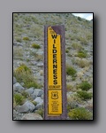
The Toiyabe Crest consists of several major roadless areas. Largest are the 99,136 acre Toiyabe Range Roadless Area and the 27,545 acre Bunker Hill Roadless Area. At 11,474 feet, Bunker Hill is a dramatic mountain with over 5000 feet of vertical relief on its eastern side. Desert Survivors and others would like to see more protection for the entire Toiyabe Crest, as well as Bunker Hill. To advocate wilderness protection for this stunning area and the animals that live there, write a letter - see sample at Wilderness Protection Advocated Visit Friends of Nevada Wilderness at www.nevadawilderness.org Friends of Nevada Wilderness is an education and advocacy group that has worked to keep Nevada's wild places wild since 1984. |
| www.landercounty.com Austin Nevada www.tonopahnevada.com/ Tonopah Nevada www.desertusa.com wild flower reports |
The Toiyabe Crest Trail is a prime backpacking destination because it travels through one of the longest roadless areas in the state, and sees fewer visitors than many Sierra trails. The Forest Service requires no fees or permits for backpacking in this area, so one may simply park and embark on this 4 - 7 day trip. Trailheads are close to Hwy 376 (which runs between Austin and Tonopah), so a single 2WD vehicle can be used to get to trailheads if one is willing to hitch-hike along Hwy 376, and walk or hitch-hike the few miles between Hwy 376 and trailheads. There is frequent vehicle traffic into and out of the Kingston trailhead. Detailed route information including location of springs is available by joining a Desert Survivors trip www.desert-survivors.org and from guidebooks such as John Hart's Sierra Club totebook "Hiking the Great Basin" and "Hiking Nevada" by Bruce Grubbs |
| California Backcountry | Inyo Mountains: Beverage Keynot McElvoy Canyons Saline Valley
Death Valley Wildflowers Wildflowers: Death Valley, Panamint Valley, Saline Valley White Mountains: Peaks, critters, bristlecone, and art in Eastern California Bodie Ghost Town: Architecture meets Fall sky. Town in arrested decay. Masonic Ghost Town: Fall colors and long vistas from mining ruin More below... |
| Nevada Backcountry | Desert Trail: Flowers and scudding clouds
Arc Dome Wilderness: Long views and big sky Jarbidge Wilderness: Alpine Beauty Spooner Summit: Fall Glory More below... |
| Utah Backcountry | Capitol Reef National Park: Fantastic shapes in many colors
San Rafael Swell: towers of angled rock |
| Backpack Light Weight | Tips, Tricks, Gear. Questions and comments welcome (after you have studied details): email Nick More below... |
|
|