What is White-Death? It is simply a
mountain/road bike ride from the highest legal point which one can ride in
California (White Mountain 14,242 ft) to the lowest point (Death Valley’s
Badwater 282 ft below sea level). The objective was to make this mountain/road bike trip
during the hottest part of the year, August of 1999 and within a 24 hour
period. Believing this had never been done before, we wanted to close out
the last summer of the millennium with a bang. Plans had to be made and a
support vehicle was needed. The total mileage was 160, elevation loss of at
least 23,000 feet with more than 9000 feet of climbing. It wasn’t all going
to be down hill!
 The plan was to drive up to
the White Mountain trailhead and bike to the summit. We planned to sleep on top
and descend early the next morning, continue down toward Wyman Creek Canyon and
on to White Mountain City. From there
we would ride on to Highway 168 over Westgard Pass and down into Fish Lake
Valley. From Fish Lake Valley continue
south on dirt roads toward Eureka Valley, and climb over the Last Chance
Mountains toward Death Valley.Once in
Death Valley we would switch to road bikes and ride the last 65 miles to
Badwater. Sounds pretty simple, as most
plans do.
The plan was to drive up to
the White Mountain trailhead and bike to the summit. We planned to sleep on top
and descend early the next morning, continue down toward Wyman Creek Canyon and
on to White Mountain City. From there
we would ride on to Highway 168 over Westgard Pass and down into Fish Lake
Valley. From Fish Lake Valley continue
south on dirt roads toward Eureka Valley, and climb over the Last Chance
Mountains toward Death Valley.Once in
Death Valley we would switch to road bikes and ride the last 65 miles to
Badwater. Sounds pretty simple, as most
plans do.
I drafted my
father and father-in-law to drive the support vehicle. The roads they would
have to follow us on
were pretty narrow with sand pits and water crossings that would swallow most
vehicles. Fortunately my father owns a
four-wheel drive pick-up that can hold our supplies as well as our bikes.
Basically they would have to keep us fed, hydrated, and supported with gear.
 We left from Sacramento on
the Thursday before the last weekend of August. There was a freak rainstorm
that came in that night and we couldn’t help but wonder if the storm would drop
any snow on the summit and how this would affect the ride off the top. The next
morning in Mammoth Lakes we could
clearly see White Mountain and its new snowcap. This could have changed our
attempt to ride off the summit;
however, we would not know until we were on the snow. That Friday we were to
ride our bikes to the summit; however, supplies had to be gathered first. We
loaded up on such items as pasta for
carbs, lean lunchmeats for protein, and fruits and vegetables to keep it
exciting. In addition, we carried
water, sports drink, and juices for hydration. Once supplied we were on
our way south on Highway 395 toward Big
Pine.This is the last stop for food
and fuel. I highly recommend topping off your tank here. Turning east on
Highway 168 and then north
toward the Ancient Bristle Cone Pine Forest follow the signs to the trailhead.
We left from Sacramento on
the Thursday before the last weekend of August. There was a freak rainstorm
that came in that night and we couldn’t help but wonder if the storm would drop
any snow on the summit and how this would affect the ride off the top. The next
morning in Mammoth Lakes we could
clearly see White Mountain and its new snowcap. This could have changed our
attempt to ride off the summit;
however, we would not know until we were on the snow. That Friday we were to
ride our bikes to the summit; however, supplies had to be gathered first. We
loaded up on such items as pasta for
carbs, lean lunchmeats for protein, and fruits and vegetables to keep it
exciting. In addition, we carried
water, sports drink, and juices for hydration. Once supplied we were on
our way south on Highway 395 toward Big
Pine.This is the last stop for food
and fuel. I highly recommend topping off your tank here. Turning east on
Highway 168 and then north
toward the Ancient Bristle Cone Pine Forest follow the signs to the trailhead.
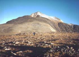
The trailhead to White Mountain is approximately
12,000 feet and the summit is at 14,242 feet. This would seem like a simple
2,000 foot climb; however, there are two
drops in the trail that eventually increase the total gain to the summit.
We hung at 12,000 feet most of the
afternoon and acclimatized as best as possible. Knowing that it would be
pretty cold on the summit and the energy
required to bike there, we took in a large pasta dinner several hours before
heading out. I highly recommend a
support crew that will take care of all of your needs. Later in the ride that
pampering becomes necessary to stay focused on the goal.
We started biking for the summit sometime
around five in the afternoon. At 12,000
feet it takes sometime to get your breathing rhythm, and the altitude makes a
small hill seem mountainous. But once
underway the ride was fairly straightforward. After about two miles the High
Altitude Research Center is reached. From here on out, the trail gets a little
steeper and more technical. Low gears
are required if not for the trail as well as the effects the altitude was
having on us. As we persist, the sun
was going down in the west and there was a noticeable temperature change. It’s that
familiar biting cold that can only
be felt in the mountains. The dryness of
the air and the cold along with the heavy breathing as I climbed created a thirst
in my throat no matter how much I tried to quench it.
After climbing descending and climbing again we reach the snow
line. The snow felt like soft mushy cold mashed potatoes. As we pushed our
bikes toward the summit,
the snow created more resistance. At
this point, we started to wonder how this snow might affect our ride down the
next morning. If it stayed soft we
would sink right through; however, if it freezes overnight it could support our
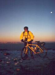
weight and make for one smooth downhill ride. We reached the summit and
found the research shack at the top locked, so
we set up tarps and our sleeping bags on the only dry spot, under an eve on
some very hard and cold concrete. The
wind began to howl and the temperature dropped. It was a very long night
of tossing and turning from discomfort
and anxiety of what the next day had in store.

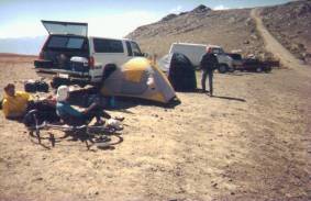
After a sleepless night we
prepared for the descent to our support crew and hot coffee. Fortunately, the
snow had hardened
overnight, and as we waited for the sun to rise we surveyed our
surroundings. To the west lay the
Palisades and Mount Whitney. To the
north the rest of the White Mountain range and to the east lay the Great Basin
of Nevada. Of course toward the south
is our goal "Death Valley". There was an orange and pink alpinglow
in the Sierras reflecting from
the new fallen snow. We readied our
gear and began the descent. I left first and then Larry followed. Except for
the occasional holes
created by the previous day’s climber's footprints, the frozen snow made for a
smooth and controllable ride. After about two miles we were back on dirt and
loose shale. The temperature had
already begun to rise. The descent was
easier than I imagined. There were
loose scree areas to negotiate; however, we were past the research center in
less than a half-hour and back at base camp in another fifteen minutes.
Once in base camp we shared stories about
the ride and the last nights weather conditions. The temperature at 12,000
feet had already warmed up so much we
were down to shorts and long sleeve tee shirts. I knew this was going to be
one long hot day.

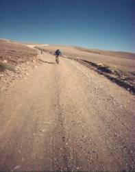
After refueling on breakfast and a quick cup of
coffee it was back on the trail. At
this point the trail was a wide graded gravel road which required us to get
into a mind numbing spin. After finally
reaching Wyman Creek Canyon road, we began what I would call an exhilarating
8,000 foot descent into the desert. We
dropped fast down an unmaintained road, over rock debris, and at least twelve
stream crossings. Some of them so deep
that my front tire would submerge to the brake pads. As we descended deeper
and deeper into the canyon, the
temperatures climbed into the upper 90’s. The cold stream crossings became more of a relief than the shock they
were higher in the canyon. We passed by
some old decaying ranch houses and never saw a single soul during the canyon
run.
At the bottom, the dirt road
became deep sand, and while we were able to stay on our bikes, the effort
hardly seemed worth it. The road eventually connected to Highway 168 near the
long deserted ghost town of White Mountain City. We turned east on 168 toward the 3,000-foot
climb up Westgard pass. The air was very dry and the temperatures
were climbing into the high 90’s. As we
climbed this steep paved road the heat waves could easily be seen on the
horizon. We climbed and saw no one and
suddenly there was a white pickup that made its way toward us. Our first
thoughts were of the support
vehicle and the cold drinks it carried. Once closer we knew it wasn’t to be so.
The vehicle was too small and a different make. The vehicle slowed down and as the occupants
rolled down their windows they asked where we came from. White Mountain was in clear view and with
our dry throats we were unable to speak loud enough so as to be heard. I just pointed
t the mountain and continued
upward.
At the summit pass, Fish
Valley lay before us. It was a steep curving downhill ride on the pavement. I
could only think of how much air I released from my tires earlier in the sandy
canyon roads below and how mushy it made the turns feel. At last, we saw the support vehicle.
It was parked at appropriately name Oasis
Road with food and drink ready for our consumption. We ate and drank and told
each other about the route. So far we were feeling pretty good. I stayed
with my hydration plan of 16 oz of sports drink an hour, along with constant
sips off my hydration pack.
After lunch, we went south on Eureka Valley
Road.The road was a dirt and sand
double track with a slight climb. Unfortunately, the previous rain had
washed the road out so that the
support vehicle could not follow. We
reevaluated the map and decided that the support vehicle would go around and
back track from the east side of Death Valley National Park and meet us some
place on the road.
For the next 30 miles Larry and I were on our
own.The temperatures were in the low
100s and the road looked long and straight. The heat waves rose over the valley
so as to look like there was a large
body of water ahead. It was a mirage of
course. We climbed a slight rise for a
few miles and once on top we began to drop into a canyon. The road was definitely
washed out and
appeared more like a dry riverbed than a road. Many times we dropped into washes that
crossed the remnants of our road.
With steep sandy drops the road was definitely not passable with a four-wheel
drive vehicle. The near vertical canyon
walls were steep and rose several hundred feet. As we dropped further into the
canyon, we noticed that the canyon floor had become so narrow that even when
the road was not washed out only one vehicle at a time could have driven
through.
As we proceeded, we came upon
a small sign that identified the Park boundary. This really gave us a sense
of accomplishment and really lifted
our sprits.We continued south and the
canyon opened up to a large valley. This was the large expanse of Eureka
Valley. Bordered by mountains
on all sides, we dropped slowly into the
sediment filled basin. We were in the
direct sun and it was getting so hot that Larry and I noticed the heat building
inside our black bike shoes. We
continue to drop until we reach a short paved road. At the intersection of
Eureka Valley and Death Valley Roads we
turned east toward Last Chance Mountain.
This short section of paved road is about 6 miles
long and climbs about 3,000 feet to Last Chance Pass. The paved section is
straight and wide open as to get full
sun.Continuing east we reached another
intersection. South Eureka Road leads
south and is much longer than the route we are taking. At the intersection there was a sign that
said Furnace Creek 86 miles. Larry
asked if our destination is before that and I am reluctant to tell him that
Badwater is at least 18 miles further. We proceed to climb to the pass and as I look at my thermometer it reads
118 degrees.This is as hot as it gets
that day, but the air is so dry that I constantly have to sip on my hydration
pack. As far as my hydration plan
goes, without our support vehicle we have to conserve. Since we last saw the support vehicle, we
were 3 hours into the ride and both of my water bottles are empty.
Occasionally, there was a slight breeze that flowed down from the pass. It was
our only relief from the relentless heat. I was overly optimistic to think
we would have traveled further then our
present location. It was extremely hard
to go more than a minute or two without a sip of water. At that rate we would
be dry by the time we
reached the pass. The going was
slow.At one point Larry estimated our
speed at a 6-mile per hour pace, we would be at the summit pass in 45
minutes. I with my speedometer didn’t
have the heart to tell him we were going closer to 3 to 4 miles per hour. As we neared
the top, I stopped to eat as
Larry continued. Suddenly, there was
the support vehicle! Larry was there
guzzling down sports drink and as I neared my energy picked up.
We ate and drank, drank and ate. We rested in the
shade of the truck and
tried to reenergize, but the heat and dehydration took too much out of us.
It was difficult to start again, but we were
determined to follow this through. Once
on the Pass, the road turned to dirt again and we began a fast steep descent
into Death Valley itself. The road was
washed out and wide, but the rock was so loose that it would be easy to lose
it. Our support vehicle went ahead to
wait at Crankshaft Junction. We flew
down and once at the bottom my hands were aching from having to brake so
much.Once at Crankshaft Junction, we
turned south and after another 20 miles we would reach the north entrance of
the Park and the beginning of the paved road. There we would switch to road
bikes and continue south toward Badwater.
The dirt road was wide, flat, and sandy.
As the sun sat behind the Last Chance Range
the temperatures finally began to drop into the 90’s. Our support vehicle went ahead
and this turned out to be a major
mistake. With the recent rains the road
was washed out in places and was sandier than usual. As it became darker we
realized that our bike lights were in the
support vehicle. As we continued to
ride southward we would drop into these washed out areas and crash. Sometimes
the drops were so severe I went over my handlebars. Fortunately for us it was
sandy enough to break our falls.
The
full moon began to rise and this helped somewhat. I would recommend radios to s
tay in contact with the support
vehicle, that way if any thing goes wrong, or assistance is needed, help is a
short call away. The support vehicle
returned out of concern for our not showing up at the ranger station.
We attached our lights and told the support
crew to get some fuel for the vehicle. Gas stations are scarce in that area
and most are closed by at least 8
p.m.Finally, we popped out onto the
paved road near the Ubehebe Crater. After another three miles, we arrived
at the ranger station somewhere
around 10 p.m.
Without our support vehicle, we decided to get some
sleep. It is amazing how comfortable
warm hard concrete can be when you are that tired. It was still pretty hot at
3,000 feet and the bugs were a real
nuisance. After about two hours of rest
our support vehicle showed up. They had
to convince a storeowner to open the pumps and sell them some fuel. We ate, and
prepared our road bikes for the
final leg of our journey. We still had
another 68 miles to go, but at least it was on paved road and a 3,000-foot
drop.
We started out ahead of the support
vehicle as they reloaded the gear. We
wanted them to drive behind us and provide some lighting with their
headlights. It was a pretty fast and
dark descent. There were no lights in
the area. The road was the same color as the shoulder. The surrounding
terrain was a combination of
a gray sandy soil and rocks blackened over time by the intense sun. In the
moonlight, everything was washed out
into a light gray or black depending on whether I was in the moonlight or
not. The contrast was so intense that
it was very hard for my eyes to adjust. I would just look straight ahead and
focus on the faded center divide
line in the middle of the road.
Descending
fast into the darkness it wasn’t until 20 miles later that the support vehicle
caught up with us. From here on out
the headlights of the support vehicle lighted our way and made it much easier
to relax our intense focus on the road. The road continued south as we dropped
toward Furnace Creek. We began
the repeated climbs, descents, climbs, and descents. I was hoping to get a
better break from the downhill, but as the
rest of the trip went, this part too would continue to have climbs. We took a
short break at Beatty Junction.
Finally, we crossed the sea level marker. This gave me a brief burst of
energy that soon faded with the next
climb.Still heading south on the North
Highway we noted these occasional cool spots. I didn’t know why they were
there, but every so often there were these
almost cold spots where the temperature was drastically lower then surrounding
areas. The difference was so great that
it almost gave me goose bumps. Later, I
found out they were salt creeks.
After a while I could see the lights of
Furnace Creek.It was still some 20
miles away, but the lights made it seem closer. I could smell the strong
scent of sage in the air. It was so
deserted out there that we only saw one car during the whole road ride from the
ranger station to Badwater. This was a
relief to me. I didn’t want to deal
with sleepy drivers passing our support vehicle and then finding us in the lane
just ahead. After a few more ups and
downs we reached Furnace Creek.Larry
and I took a break at the visitor’s center and began to contemplate our
motivation to Badwater. A little rest
and food are a good thing. Once our
bodies were partially restored with fuel we could think straight enough to
realize the necessity of pushing forward.

Climbing back into the
saddle of my bike, that familiar muscle pain quickly resumed. It was 3:30 a.m.
and as we looked at the
only two hotels in town it was easy to fantasize about checking in for the
night.Just south of town the road to
Badwater is clearly marked and begins to turn southwest. Only 18 miles to go!
I try to think of it as the start of a
casual ride around home. I thought to
myself 18 miles that’s not at all far. It’s only as far as a bike
commute to work, or a ride around Lake
Natoma. No big deal, this will be
easy. In reality we are both slowing
down.
On our left, there are mountains and cliffs and as we descend they appear
to get taller. On our right, a flat dry
salt lakebed has gotten larger the further we rode.The moonlight reflected on
the dry lake causing an almost pure
white, like sugar spread across a white countertop. I continued to see faint
road signs in the distance that while I
knew were not indicators of our goal I still hoped they were. We passed
several roads such as Artist Drive
and Natural Bridge Road. Suddenly, we
saw a sign that read “Badwater Ľ Mile”. I could hardly believe it. We
rolled into the graveled parking lot and are the only ones there. No surprise,
since it is 4:30 am. No fan fair, just a beer at a picnic table
and a few pictures around the sign that marks “Badwater –282 feet”. Up on a cliff
there was another sign that
marked sea level.
There was this
familiar joy and sadness when a goal is first reached. I was glad it is over,
but at the same time
I felt like I should have been more excited about this accomplishment. Also, I
couldn’t help but feel a little sad that all the planning, and talking to
friends about the trip is over. All I
can do now is plan another trip. Maybe
next time a ride from Badwater to White Mountain?
Two years later my wife and I are at Badwater.
We look around and it is full of tourists. Some amazed at the vastness,
and some congratulating themselves for just being there. I wanted to tell everyone of White-Death,
but I don’t. Who would believe me? Would they even care? As I listened to
each of them, and I realized that each person’s adventure is not how they get
there. It’s just getting out
there.
(All altitudes, gains, losses and mileages herein are estimates).